
Tropical Storm Humberto and Imelda: Rare Fujiwhara Effect Could Threaten the U.S. East Coast
The Atlantic hurricane season 2025 is intensifying, and two storms could shape into a rare and dangerous scenario. Meteorologists are closely watching Tropical Storm Humberto in the Atlantic and another system, Invest 94L, which may soon be named Tropical Storm Imelda.
If the two storms get close enough, they could interact through the Fujiwhara Effect, a rare phenomenon that sometimes creates one giant storm. This could raise serious risks for the U.S. East Coast, especially the Carolinas and Southeast states.
Here’s what you need to know about Tropical Storm Humberto, Tropical Storm Imelda, and the Fujiwhara Effect — and how they might affect millions of people next week.
Key Facts at a Glance
-
Tropical Storm Humberto is strengthening and could become a Category 3 or 4 hurricane this weekend.
-
Invest 94L, soon to be Tropical Storm Imelda, is moving across the Caribbean and may reach the Bahamas this weekend.
-
If close enough, Humberto and Imelda could trigger the Fujiwhara Effect, a rare storm interaction.
-
The Carolinas and Southeast U.S. have the highest risk for land impacts early next week.
-
Even without a direct hit, both storms could cause flooding, heavy rain, and dangerous surf along the East Coast.
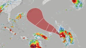
Tropical Storm Humberto: Rapidly Intensifying
Current Status
-
Location: Several hundred miles northeast of the Leeward Islands.
-
Wind Speeds: Near 50 mph, moving northwest at 8 mph.
-
Forecast: Expected to become a hurricane by Friday night and strengthen into a major Category 3–4 hurricane this weekend.
Tropical Storm Humberto is not currently a threat to the Caribbean. However, it could pass close to Bermuda early next week and create powerful swells across much of the Atlantic.
Meteorologists warn that even though Tropical Storm Humberto may not directly hit the U.S., its interaction with Tropical Storm Imelda could shift weather patterns along the East Coast.
The Development of Tropical Storm Imelda
What Is Invest 94L?
The system called Invest 94L is a disorganized group of thunderstorms moving across the northern Caribbean. Forecasters say it has a high chance of becoming Tropical Storm Imelda in the next 24–48 hours.
Impacts So Far
-
Puerto Rico & Virgin Islands: Heavy rainfall, flooding, and gusty winds.
-
Hispaniola (Dominican Republic & Haiti): Landslide risks in mountainous regions.
Forecast Track
-
Likely to become Tropical Storm Imelda near the Bahamas by Saturday.
-
Could approach the Southeast U.S. coast early next week.
-
Final path will depend on how it interacts with Tropical Storm Humberto and the U.S. jet stream.
Why the Forecast Is Tricky
The interaction between Tropical Storm Humberto and Tropical Storm Imelda creates several uncertainties:
-
Humberto’s Role
-
A stronger Humberto could pull Imelda away into the Atlantic.
-
A weaker Humberto may allow Imelda to move closer to the U.S. coast.
-
-
The Jet Stream
-
A dip in the eastern U.S. jet stream could drag Tropical Storm Imelda toward the Carolinas.
-
If the jet stream shifts east, Imelda may stay offshore.
-
-
The Fujiwhara Effect
-
If Humberto and Imelda come within 900 miles of each other, the Fujiwhara Effect could make them spin around a common center.
-
This rare weather dance could either fling Imelda out to sea or push it dangerously closer to land.
-
What Is the Fujiwhara Effect?
The Fujiwhara Effect, named after Japanese meteorologist Sakuhei Fujiwhara in 1921, occurs when two storms orbit one another.
Key Facts About the Fujiwhara Effect
-
Happens when two tropical storms are within 900 miles.
-
Outcomes vary depending on storm strength:
-
Weaker storm pulled away into the ocean.
-
Stronger storm absorbs the weaker one.
-
Both whirl around a shared point before breaking apart.
-
Examples from past storms include:
-
Hurricanes Hilary and Irwin (2017): Danced around each other before weakening.
-
Typhoon Hinnamnor (2022): Absorbed a weaker storm in the West Pacific.
In the Atlantic, the Fujiwhara Effect is rare but not impossible. The concern now is whether Tropical Storm Humberto and Tropical Storm Imelda could perform this dangerous “storm dance” near the U.S. coast.
Potential Threats to the U.S. East Coast
Even without colliding, Tropical Storm Humberto and Tropical Storm Imelda could bring hazards to millions.
Possible Scenarios
-
Direct Landfall: If Imelda avoids Humberto’s pull, it could strike the Carolinas or Georgia by Monday or Tuesday.
-
Close Offshore Pass: Even without landfall, dangerous rip currents, storm surge, and heavy rain could threaten the coast.
-
No U.S. Impact: If Humberto dominates, Imelda may be pushed safely out to sea.
Secondary Risks
-
Flooding rain in the Southeast and Mid-Atlantic.
-
High surf and rip currents along beaches from Florida to the Outer Banks.
-
Travel disruptions due to storm warnings and airline cancellations.
Timeline: What to Expect
-
Thursday–Friday: Heavy rain from Invest 94L (future Imelda) impacts Puerto Rico and Hispaniola. Tropical Storm Humberto strengthens in the Atlantic.
-
Saturday–Sunday: Invest 94L develops into Tropical Storm Imelda near the Bahamas. Humberto becomes a major hurricane.
-
Monday–Tuesday: Possible U.S. impacts, with the Carolinas most at risk for landfall or flooding.
How to Prepare Along the Coast
With two storms in play, residents along the Southeast and East Coast should stay ready:
-
Stay Updated: Follow the National Hurricane Center (NHC) and NOAA for updates.
-
Emergency Supplies: Stock water, food, flashlights, batteries, and medications.
-
Plan Evacuations: Review local evacuation routes.
-
Monitor Local Alerts: Don’t rely on rumors—stick to official forecasts.
Expert Opinions
Greg Diamond, meteorologist at Fox Weather, explained:
“The Fujiwhara Effect is when storms close together, interact, and rotate around each other. For tropical systems, they must be within 900 miles. What happens depends on each storm’s strength—sometimes they merge, sometimes one absorbs the other.”
The National Weather Service (NWS) also highlights the complexity:
“When the Fujiwhara Effect happens, the forecast becomes extremely difficult. The outcome depends on storm strength, distance, and timing.”
Conclusion: Stay Alert, Stay Prepared
The coming days could shape the most dramatic moment of the Atlantic hurricane season 2025 so far. Tropical Storm Humberto is almost certain to become a major hurricane, while Tropical Storm Imelda is expected to develop in the Caribbean.
If they interact through the Fujiwhara Effect, the outcome could range from a harmless dance at sea to a dangerous impact on the U.S. East Coast.
For now, the only certainty is uncertainty. Forecasts will keep changing, but the risk to the Carolinas and Southeast cannot be ignored.
Residents should remain cautious, prepare early, and check official updates daily.
References
Read Also This: Is the US Going to War? The Truth Behind the Pentagon’s Secret Meeting